X2, the only mapping application you'll ever need. I'm not sure why people still spend the $$ on handheld gps. I've found Navionics to be very accurate, you can mark waypoints, it will trace the route you have taken, points in the direction you are traveling, you can adjust the water levels for lakes that have had level changes. It's all you need.
X3, Std. Boating App is $9.95 for U.S.A. Region, U.S.A + Canada $14.95 for first year, $4.95 renewal for U.S.A. The Navionics site has a U.S. map where you can view all lakes for U.S. which is the same as the Navionics map view on the App. The SonarChart map view are updated maps where users have linked the Boating App to one of the WiFi fish finders. I personally use the Vexilar FishPhone. When on the lake, you turn on the SonarChart Live feature and the lake depth at your exact GPS location is recorded about every second. This recorded depth/GPS data is than sent to Navionics (next time you are on WiFi) and incorporated into map updates. Within a week you can download updated maps which includes the new contours you recorded.
These are 3 screen shots of a hump on a lake I fish summer and winter.
Winter screen shot Jan 2016
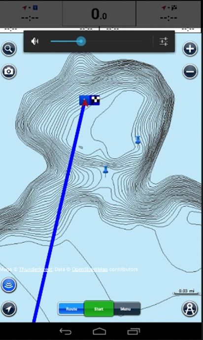
The top of the hump marked at 8'. The two pins are waypoints of where I set up my wheelhouse and caught some walleye. The outside contours are 45' deep with the depth continued down to 154'. I set my max depth at 45'.
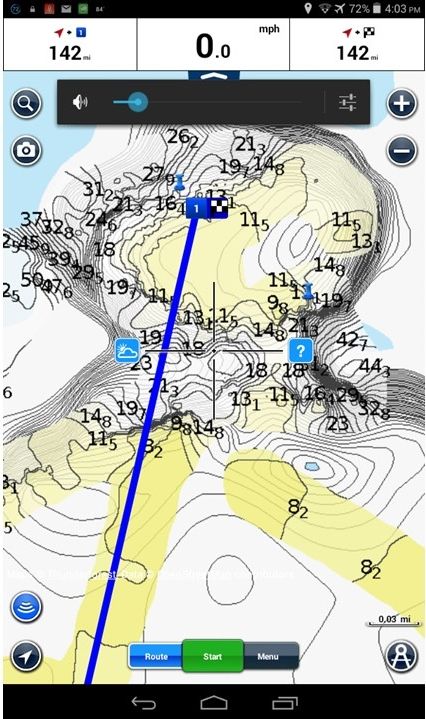
This second screen shot is this past June when I turned on the SorarChart Live and fished the entire hump. The two pins are where I caught the most fish and ideal spots for this coming winter. Other boaters were in this area which I know were also using the Boating App so their SonarChart Live recordings where also compiled with mine when Navionics did a map update.
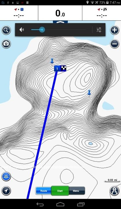
This last screen shot I did about a week after I returned home and downloaded the map update. The high point on the hump is actually 5.4' and the contours are now exact to what I recorded. Most of the time I was between 9 and 16 FOW so the outside contour at 45' remained somewhat the same. The blue line is a route line from the fishing spot to the lake access about 1.6 miles away. Really nice to have at 1:00 AM insuring you avoid the open water areas on the lake when going home or to cabin.
There are usually lots of concerns about battery use, and yes the built in GPS chip on the 7" tablet I use does deplete the battery in about 3 hours. Not a problem as I connect the car charger to my boat battery. In winter when in my Hub, I use one of the 2000mhr cell phone charge batteries about twice the size of a Cig. lighter. Runs my phone all day.


